When it comes to surveying existing buildings laser scanning offers a multitude of advantages - it's a relatively quick and precise way to capture 3D data as a point cloud. All this data can then be used to create an accurate parametric 3D model that can be used to aid the design process, make better decisions or assess progress on a project.
What is laser scanning?
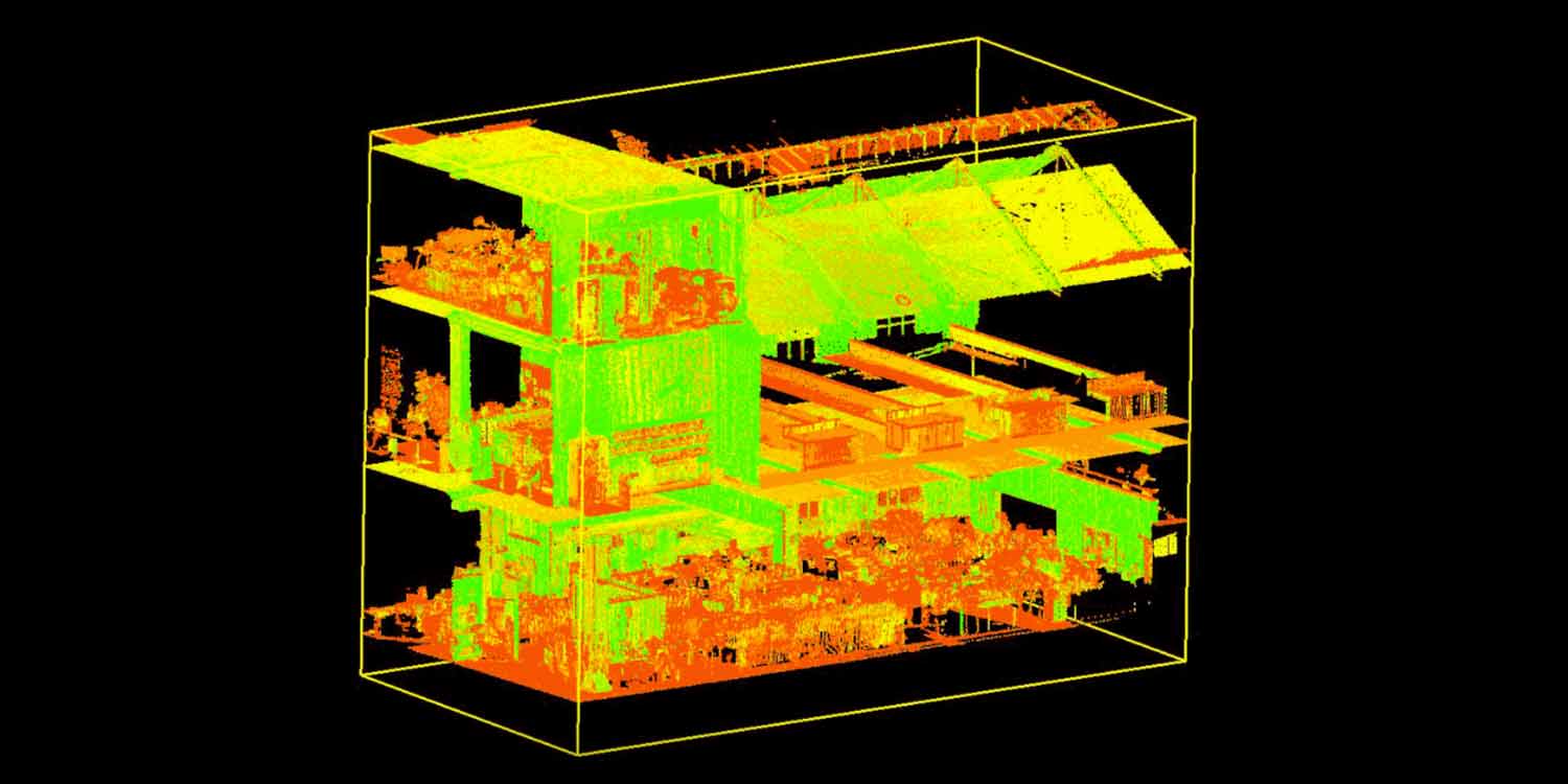
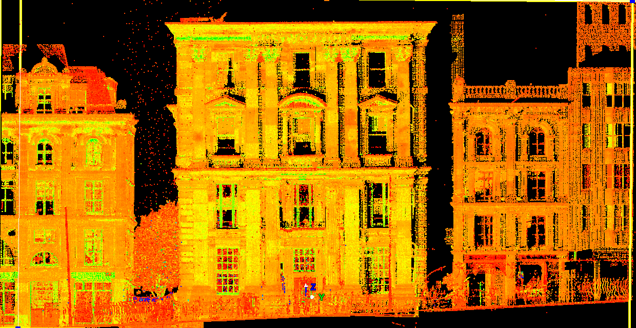
Light Detection and Ranging (RIDA), more commonly known as 3D laser scanning, is a non-contact technology that allows the shape of physical objects to be digitally captured using a line of laser light forming 'point clouds' of data from the surface of an object.
The technology has its origins in airbourne submarine detection but applications for architecture and construction (for both airbourne and ground-based surveying) are becoming more popular.
How does laser scanning work?
The laser scanner works by rotating a pulsed laser light at high speed and measuring reflected pulses with a sensor. The scanner automatically rotates around its vertical axis and an oscilating mirror moves the beam up and down. The result is a sweeping of the beam over the scan area. As the laser light hits objects or materials the scanner makes a note of their position in relation to the scanner based on the time it takes for each pulse of light to be bounced back. Given that light moves at a constant and known speed the scanner can easily calculate the distance between the scanner and an object. Additionally data on the horizontal angle of the rotating laser and the corresponding vertical angle of the rotating mirror is also captured. The result is a corresponding X, Y and Z co-ordinate position for each 'point'. These points, begin to build up as the device gets to work, and as more points are collected an accurate 3D representation of the scene being scanned starts to emerge. Because the laser light emitted by the scanner can only travel in a straight line, you'll need to undertake a number of scans from a range of positions, to ensure complete coverage. Adding more points to your point cloud increases the resolution of your scan - you can also merge photos with scan data or reference geo-coordinate systems.
Laser scanners can capture an enormous amount of data - potentially a million unique points each and every second - so before you get to work on-site you should think about what the data you are about to collect will be used for. Being clear from the off will help you determine an appropriate scan area (and appropriate scan targets) and understand the required resolution, which should save you time and effort.
What kind of laser scanners are available?
There are different kinds of scanners but they all work on the same basic principle.
Laser scanners are available that work at close range (covering very small objects or detailed surfaces observed from less than half a metre) or at ranges between 20m to 2km (with accuracy ranging from a few mm to 100mm).
Airbourne scans, typically taken from a helicopter are also possible though obviously accuracy decreases at this higher vantage point.
Most modern scanners are relatively small and lightweight and can easily affix to a standard tripod. Indeed, subject to site conditions and the scale of the task in hand, they can easily be operated by just one person.
How can you use and manipulate data from a laser scanning process?
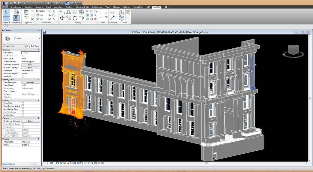
Data can be extracted from most scanner units by either connecting the device to a PC or saving down the data to a USB memory stick. This raw scan data can then be calibrated in a software program allowing analysis and modelling. Importing the raw data for calibration can be quite fiddly and may benefit from a specialist to ensure everything comes together properly. Firms offering scanning and calibration services are easily found online.
Crucially, the laser scanned data (once calibrated) can easily be imported into BIM authoring tools such as Autodesk Revit or Bentley MicroStation, and many programs offer a built-in point cloud engine or similar functionality via plug-in. Once imported the various elements of surfaces and buildings and dependencies are maintained and presented and able to be manipulated using the tools at hand.
What are the benefits of laser scanning?
By allowing designers, project managers and contractors to benefit from information on existing conditions from an early stage and throughout a BIM project, better decisions can be made.
Laser scanning also offers major time saving benefits. Traditional surveying techniques will take much, much longer so by opting for a laser scan you are likely to collect significantly higher volumes of data in much less time. This speed means that survey data can be collated and shared with those on the project team who need it much more quickly, allowing the team to get on with design work, project scoping or verifying progress on site.
Other benefits of laser scanning include more complete and accurate delivery, better off-site fabrication and less on site modification. Scans also should reduce the need, or even eliminate entirely the need for site revisits, resulting in faster and cheaper project turnaround.
Laser scanning through the project timeline
Here's some of the major benefits at key project stages.
Pre-construction
Being able to visualise buildings in a virtual environment before they are even built allows you to test concepts and understand the full impacts of the decisions being made before turf is even cut.
A pre-construction laser scan can provide an accurate view of the site onto which structures can be placed eliminating the potential for nasty surprises as you move from design to construction.
Laser scanning offers significant potential to make time and cost savings and particularly comes into its own when dealing with difficult conditions on construction sites - those with variable or inaccessible terrain, underground areas, or poses access problems or other risks were a human to survey.
Construction
Laser scans at the construction phases offers a number of advantages - not least the ability to quickly check the progress of a project against initial designs and plans by way of footprints, elevations, sections and 3D models. Such scans are also invaluable when it comes to quality control processes.
And it's not just external assembly where laser scanning comes in useful - it's equally handy when fitting out interiors, creating a full record scan, 2D floor plans, internal elevations or a full 3D model as construction edges to completion.
Post-Construction
A laser scan can quickly deliver data for an as-built model with data proving invaluable for facilities management and even for those who, years down the line, may be called upon to renovate or even demolish the building.
What other applications?
It's not just architecture that stands to benefit from laser scanning technology - it's also proving invaluable to provide forensic analysis of accidents or crime scenes - in fact, anywhere a data-rich snapshot of a moment in time can be captured and then analysed.
Indeed, there are a myriad of uses for laser scanning ranging from forestry management, to flood modelling, pollution modelling, coastline management, and general mapping and planning.
Share your experiences
We'd love to hear about your experiences using laser scanning technology. What projects have benefited from laser scans? How easy (or difficult) was the whole process? What were the key benefits? What lessons did you learn along the way? We're looking to follow up on this feature with some real-life case studies - get in touch to share your thoughts and tell us about your projects.
What to read next...
Point cloud surveys
NBS's Dr Stephen Hamil provides a quick explanation of what point cloud surveys are and some of the advantages.
Putting the 'I' into BIM
We explore the information at the heart of a BIM workflow.